Friday, October 26, 2007


another windy fall

So last week it was the neighbors tree that fell and then today a big branch from a tree in my yard fell. Here are two pictures.
Saturday, October 20, 2007
Steve Pierce Winter Forecast
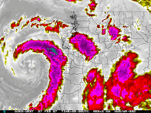
Blog writer and "weather geek" put out his Winter Forecast a few weeks ago. Take a look at it. Steve won't be presenting at the AMS Winter Weather Meeting, but some of his information will make it into a presentation.
Steve Pierce Forecast
Steve Pierce Forecast
Tree Falls In Beaverton
I'm watching another great Saturday of college football when I see a movement of something out of the corner of my eye. I quickly look to the left and see a tree slamming into the house across the street. I grabbed my camera and clicked a few pictures ! The wind was blowing all that hard. I'm guessing the tree rotted and just went over. There were a ton of bees flying around the base. Looks like they will have to find a new home.
Bobby


Bobby
Wednesday, October 17, 2007
Skywarn and Ham Operator Working to Save Lives !
This an article about a skywarn member in Michigan who is working to save lives.
Thursday, October 11, 2007
Remembering The Mother Of All Storms
Yes thats right. October 12th, 1962...The Columbus Day Storm. This is the measuring stick that all of the pacific storms are judged by. The storm is one of the most powerful to ever strike the United States. Millions of board feet of timber were destroyed and tons of weather stations were taken off line as they were either blown away or hit by debris. I wasn't around in '62, but after watching old news footage, I'm glad I wasn't here to see it in person, I just hope I get to see a storm close to that soon.
Here is a video of the Dec. 12th 2006 storm that brought high winds to the coast and the valley !
Here is a video of the Dec. 12th 2006 storm that brought high winds to the coast and the valley !
Saturday, October 6, 2007
Portland NWS Open House

Today was the NWS open house in Portland. It was a cool event to attend. I was handing out information about the Oregon AMS and just chatting with the forecasters and fellow weather fans. Most of the focus from my stand point was the upcoming wind event on Tuesday.
 It was very interesting to see the NWS forecasters sort through the information and really explain to all of us the dynamics and the reasons why it might not happen this time. Steve Pierce, blog writer and weather nut also made an appearance. This guy is all about the snow and windstorm. He is a valuable resource to this blog and the others that he posts information. It was very cool to see the different tools that are available to the NWS.
  I was blown away at the technology that they had at their disposal. I was very jealous that they have all the information available, just a click away. The day started with a quick overall briefing of the national weather service and who they are and what they do. The entire staff was friendly and willing to talk. I was very impressed with them all. I had a chance to sit down with Tyree Wilde, the Warning Coordination Meteorologist from the Portland NWS WFO (Weather Forecast Office) and chat about the new Storm Based Warning System. Move your mouse over the link and the player will appear and click play. To download the interview, simply click the link.
Tyree Wilde Storm Based Warning
Thursday, October 4, 2007
Funnel Cloud in da Couv !
From PDX NWSFO !
SHORT TERM FORECAST NATIONAL WEATHER SERVICE PORTLAND OR 542 PM PDT THU OCT 4 2007 WAZ023-039-040-050115- GREATER VANCOUVER AREA-SOUTH WASHINGTON CASCADE FOOTHILLS- WESTERN COLUMBIA RIVER GORGE- 542 PM PDT THU OCT 4 2007 .NOW... AT 542 PM PDT NATIONAL WEATHER SERVICE DOPPLER RADAR INDICATED A THUNDERSTORM NEAR I-205 AND WASHINGTON HIGHWAY 14...OR ABOUT 8 MILES SOUTHEAST OF BATTLE GROUND...MOVING NORTHEAST AT 15 MPH. A TRAINED WEATHER SPOTTER REPORTED A FUNNEL CLOUD ASSOCIATED WITH THIS THUNDERSTORM. SMALL HAIL...HEAVY RAIN...GUSTY WINDS UP TO 35 MPH...AND DANGEROUS LIGHTNING CAN BE EXPECTED IN THIS AREA.
Photos can be found at the Storm Team 12 Blog ! Storm Team 12 Blog
Wednesday, October 3, 2007
Wild Upcoming Weather ?
I've spent the last half hour looking at maps for Tuesday and Thursday of next week. Many models have deep low pressure systems heading this way. Steve Pierce, blog contributor and fellow weather geek is saying that some models bring it on course for a good wind event, while the Euro takes it out farther in the ocean. Only time will tell. All of us are waiting for the next MM5 run to come in. That will be about 1am pacific. The Drought Monitor conference is next week as well. If the models start to get some consistency on the location of the low and it does infact look like a wind event, you will have a giant gathering of weather people in Portland. That could be a very cool thing to see !
Subscribe to:
Posts (Atom)